Portrait de David Rolnick

David Rolnick

Membre académique principal
Chaire en IA Canada-CIFAR
Professeur adjoint, McGill University, École d'informatique
Professeur associé, Université de Montréal, Département d'informatique et de recherche opérationnelle
Sujets de recherche
Apprentissage automatique appliqué
Apprentissage automatique dans la modélisation climatique
Apprentissage automatique et changement climatique
Apprentissage automatique pour les sciences physiques
Biodiversité
Changement climatique
Climat
Détection hors distribution (OOD)
IA et durabilité
IA pour la science
IA pour le changement climatique
Modélisation climatique
Prévision des séries temporelles
Réduction d'échelle des variables climatiques
Science du climat
Surveillance des forêts
Systèmes de gestion de l'énergie des bâtiments
Systèmes énergétiques
Technologie de conservation
Télédétection
Télédétection par satellite
Théorie de l'apprentissage automatique
Végétation
Vision par ordinateur

Biographie

David Rolnick est professeur adjoint et titulaire d’une chaire en IA Canada-CIFAR à l'École d'informatique de l'Université McGill et membre académique principal de Mila – Institut québécois d’intelligence artificielle. Ses travaux portent sur les applications de l'apprentissage automatique dans la lutte contre le changement climatique. Il est cofondateur et président de Climate Change AI et codirecteur scientifique de Sustainability in the Digital Age. David Rolnick a obtenu un doctorat en mathématiques appliquées du Massachusetts Institute of Technology (MIT). Il a été chercheur postdoctoral en sciences mathématiques à la National Science Foundation (NSF), chercheur diplômé à la NSF et boursier Fulbright. Il a figuré sur la liste des « 35 innovateurs de moins de 35 ans » de la MIT Technology Review en 2021.

Étudiants actuels

Collaborateur·rice de recherche
Collaborateur·rice alumni - McGill
Collaborateur·rice de recherche - Cambridge University
Co-superviseur⋅e :
Postdoctorat - McGill
Collaborateur·rice de recherche - McGill
Collaborateur·rice de recherche
Collaborateur·rice de recherche - N/A
Co-superviseur⋅e :
Maîtrise recherche - McGill
Collaborateur·rice de recherche - Leipzig University
Maîtrise recherche - McGill
Collaborateur·rice de recherche
Visiteur de recherche indépendant - Politecnico di Milano
Visiteur de recherche indépendant
Collaborateur·rice de recherche - UdeM
Collaborateur·rice de recherche - Johannes Kepler University
Collaborateur·rice de recherche - University of Amsterdam
Maîtrise recherche - McGill
Collaborateur·rice de recherche
Visiteur de recherche indépendant - Université de Montréal
Collaborateur·rice de recherche - Polytechnique Montréal
Collaborateur·rice de recherche - University of East Anglia
Collaborateur·rice de recherche
Collaborateur·rice de recherche - Columbia university
Postdoctorat - McGill
Co-superviseur⋅e :
Collaborateur·rice de recherche - University of Waterloo
Co-superviseur⋅e :
Collaborateur·rice alumni - UdeM
Maîtrise recherche - McGill
Collaborateur·rice de recherche - Columbia university
Maîtrise recherche - McGill
Collaborateur·rice de recherche - University of Tübingen
Collaborateur·rice de recherche - Karlsruhe Institute of Technology
Doctorat - McGill
Postdoctorat - UdeM
Superviseur⋅e principal⋅e :
Collaborateur·rice de recherche
Doctorat - McGill
Collaborateur·rice alumni - McGill

Publications

Assessing SAM for Tree Crown Instance Segmentation from Drone Imagery
Mélisande Teng
Etienne Lalibert'e
A Joint Space-Time Encoder for Geographic Time-Series Data
Konstantin Klemmer
Mélisande Teng
Many real-world processes are characterized by complex spatio-temporal dependencies, from climate dynamics to disease spread. Here, we intro… (voir plus)duce a new neural network architecture to model such dynamics at scale: the \emph{Space-Time Encoder}. Building on recent advances in \emph{location encoders}, models that take as inputs geographic coordinates, we develop a method that takes in geographic and temporal information simultaneously and learns smooth, continuous functions in both space and time. The inputs are first transformed using positional encoding functions and then fed into neural networks that allow the learning of complex functions. We implement a prototype of the \emph{Space-Time Encoder}, discuss the design choices of the novel temporal encoding, and demonstrate its utility in climate model emulation. We discuss the potential of the method across use cases, as well as promising avenues for further methodological innovation.
OpenForest: a data catalog for machine learning in forest monitoring
Teja Kattenborn
Etienne Lalibert'e
Harnessing artificial intelligence to fill global shortfalls in biodiversity knowledge
Justin Kitzes
Sara Beery
Kaitlyn M. Gaynor
Marta A. Jarzyna
Oisin Mac Aodha
Bernd Meyer
Graham W. Taylor
Devis Tuia
Tanya Berger-Wolf
Galileo: Learning Global and Local Features in Pretrained Remote Sensing Models
Anthony Fuller
Henry Herzog
Patrick Beukema
Favyen Bastani
James R Green
Evan Shelhamer
Hannah Kerner
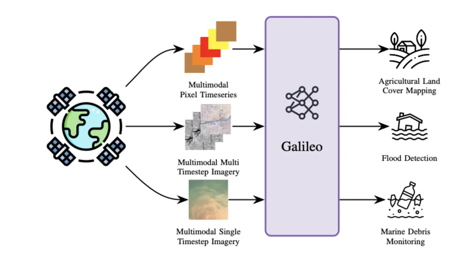
From crop mapping to flood detection, machine learning in remote sensing has a wide range of societally beneficial applications. The commona… (voir plus)lities between remote sensing data in these applications present an opportunity for pretrained machine learning models tailored to remote sensing to reduce the labeled data and effort required to solve individual tasks. However, such models must be: (i) flexible enough to ingest input data of varying sensor modalities and shapes (i.e., of varying spatial and temporal dimensions), and (ii) able to model Earth surface phenomena of varying scales and types. To solve this gap, we present Galileo, a family of pretrained remote sensing models designed to flexibly process multimodal remote sensing data. We also introduce a novel and highly effective self-supervised learning approach to learn both large- and small-scale features, a challenge not addressed by previous models. Our Galileo models obtain state-of-the-art results across diverse remote sensing tasks.
Galileo: Learning Global and Local Features in Pretrained Remote Sensing Models
A. Fuller
Henry Herzog
Patrick Beukema
Favyen Bastani
James R. Green
Evan Shelhamer
Hannah Kerner
From crop mapping to flood detection, machine learning in remote sensing has a wide range of societally beneficial applications. The commona… (voir plus)lities between remote sensing data in these applications present an opportunity for pretrained machine learning models tailored to remote sensing to reduce the labeled data and effort required to solve individual tasks. However, such models must be: (i) flexible enough to ingest input data of varying sensor modalities and shapes (i.e., of varying spatial and temporal dimensions), and (ii) able to model Earth surface phenomena of varying scales and types. To solve this gap, we present Galileo, a family of pretrained remote sensing models designed to flexibly process multimodal remote sensing data. We also introduce a novel and highly effective self-supervised learning approach to learn both large- and small-scale features, a challenge not addressed by previous models. Our Galileo models obtain state-of-the-art results across diverse remote sensing tasks.
Galileo: Learning Global&Local Features of Many Remote Sensing Modalities
A. Fuller
Henry Herzog
Patrick Beukema
Favyen Bastani
James R. Green
Evan Shelhamer
Hannah Kerner
We introduce a highly multimodal transformer to represent many remote sensing modalities - multispectral optical, synthetic aperture radar, … (voir plus)elevation, weather, pseudo-labels, and more - across space and time. These inputs are useful for diverse remote sensing tasks, such as crop mapping and flood detection. However, learning shared representations of remote sensing data is challenging, given the diversity of relevant data modalities, and because objects of interest vary massively in scale, from small boats (1-2 pixels and transient) to glaciers (thousands of pixels and persistent). We present a novel self-supervised learning algorithm that extracts multi-scale features across a flexible set of input modalities through masked modeling. Our dual global and local contrastive losses differ in their targets (deep representations vs. shallow input projections) and masking strategies (structured vs. not). Our Galileo is a single generalist model that outperforms SoTA specialist models for satellite images and pixel time series across eleven benchmarks and multiple tasks.
Using Image-based AI for insect monitoring and conservation - InsectAI COST Action
Tom August
Mario Balzan
Paul Bodesheim
Gunnar Brehm
Lisette Cantú-Salazar
Sílvia Castro
Joseph Chipperfield
Guillaume Ghisbain
Alba Gomez-Segura
Jérémie Goulnik
Quentin Groom
Laurens Hogeweg
Chantal Huijbers
Andreas Kamilaris
Karolis Kazlauskis
Wouter Koch
Dimitri Korsch
João Loureiro
Youri Martin
Angeliki Martinou … (voir 27 de plus)
Kent McFarland
Xavier Mestdagh
Denis Michez
Charlie Outhwaite
Luca Pegoraro
Nadja Pernat
Lars Pettersson
Pavel Pipek
Cristina Preda
Tobias Roth
David Roy
Helen Roy
Veljo Runnel
Martina Sasic
Dmitry Schigel
Julie Sheard
Cecilie Svenningsen
Heliana Teixeira
Nicolas Titeux
Thomas Tscheulin
Elli Tzirkalli
Marijn van der Velde
Roel van Klink
Nicolas Vereecken
Sarah Vray
Toke Thomas Høye
Task-Informed Meta-Learning for Remote Sensing
Insect Identification in the Wild: The AMI Dataset
M. J. Bunsen
L. Pasi
N. Pinoy
Flemming Helsing
JoAnne Russo
Marc Botham
Michael Sabourin
Jonathan Fréchette
Alexandre Anctil
Yacksecari Lopez
Eduardo Navarro
Filonila Perez Pimentel
Ana Cecilia Zamora
José Alejandro Ramirez Silva
Jonathan Gagnon
Tom August
K. Bjerge … (voir 8 de plus)
Alba Gomez Segura
Marc Bélisle
Yves Basset
K. P. McFarland
David Roy
Toke Thomas Høye
Maxim Larrivée
Insects represent half of all global biodiversity, yet many of the world's insects are disappearing, with severe implications for ecosystems… (voir plus) and agriculture. Despite this crisis, data on insect diversity and abundance remain woefully inadequate, due to the scarcity of human experts and the lack of scalable tools for monitoring. Ecologists have started to adopt camera traps to record and study insects, and have proposed computer vision algorithms as an answer for scalable data processing. However, insect monitoring in the wild poses unique challenges that have not yet been addressed within computer vision, including the combination of long-tailed data, extremely similar classes, and significant distribution shifts. We provide the first large-scale machine learning benchmarks for fine-grained insect recognition, designed to match real-world tasks faced by ecologists. Our contributions include a curated dataset of images from citizen science platforms and museums, and an expert-annotated dataset drawn from automated camera traps across multiple continents, designed to test out-of-distribution generalization under field conditions. We train and evaluate a variety of baseline algorithms and introduce a combination of data augmentation techniques that enhance generalization across geographies and hardware setups.
Alberta Wells Dataset: Pinpointing Oil and Gas Wells from Satellite Imagery
Brefo Dwamena Yaw
Jade Boutot
Mary Kang
Millions of abandoned oil and gas wells are scattered across the world, leaching methane into the atmosphere and toxic compounds into the gr… (voir plus)oundwater. Many of these locations are unknown, preventing the wells from being plugged and their polluting effects averted. Remote sensing is a relatively unexplored tool for pinpointing abandoned wells at scale. We introduce the first large-scale benchmark dataset for this problem, leveraging medium-resolution multi-spectral satellite imagery from Planet Labs. Our curated dataset comprises over 213,000 wells (abandoned, suspended, and active) from Alberta, a region with especially high well density, sourced from the Alberta Energy Regulator and verified by domain experts. We evaluate baseline algorithms for well detection and segmentation, showing the promise of computer vision approaches but also significant room for improvement.