Portrait de David Rolnick

David Rolnick

Membre académique principal
Chaire en IA Canada-CIFAR
Professeur adjoint, McGill University, École d'informatique
Professeur associé, Université de Montréal, Département d'informatique et de recherche opérationnelle
Sujets de recherche
Apprentissage automatique appliqué
Apprentissage automatique dans la modélisation climatique
Apprentissage automatique et changement climatique
Apprentissage automatique pour les sciences physiques
Biodiversité
Changement climatique
Climat
Détection hors distribution (OOD)
IA et durabilité
IA pour la science
IA pour le changement climatique
Modélisation climatique
Prévision des séries temporelles
Réduction d'échelle des variables climatiques
Science du climat
Surveillance des forêts
Systèmes de gestion de l'énergie des bâtiments
Systèmes énergétiques
Technologie de conservation
Télédétection
Télédétection par satellite
Théorie de l'apprentissage automatique
Végétation
Vision par ordinateur

Biographie

David Rolnick est professeur adjoint et titulaire d’une chaire en IA Canada-CIFAR à l'École d'informatique de l'Université McGill et membre académique principal de Mila – Institut québécois d’intelligence artificielle. Ses travaux portent sur les applications de l'apprentissage automatique dans la lutte contre le changement climatique. Il est cofondateur et président de Climate Change AI et codirecteur scientifique de Sustainability in the Digital Age. David Rolnick a obtenu un doctorat en mathématiques appliquées du Massachusetts Institute of Technology (MIT). Il a été chercheur postdoctoral en sciences mathématiques à la National Science Foundation (NSF), chercheur diplômé à la NSF et boursier Fulbright. Il a figuré sur la liste des « 35 innovateurs de moins de 35 ans » de la MIT Technology Review en 2021.

Étudiants actuels

Collaborateur·rice de recherche
Collaborateur·rice alumni - McGill
Collaborateur·rice de recherche - Cambridge University
Co-superviseur⋅e :
Postdoctorat - McGill
Collaborateur·rice de recherche - McGill
Collaborateur·rice de recherche
Collaborateur·rice de recherche - N/A
Co-superviseur⋅e :
Maîtrise recherche - McGill
Collaborateur·rice de recherche - Leipzig University
Collaborateur·rice de recherche
Visiteur de recherche indépendant - Politecnico di Milano
Visiteur de recherche indépendant
Collaborateur·rice de recherche - UdeM
Collaborateur·rice de recherche - Johannes Kepler University
Collaborateur·rice de recherche - University of Amsterdam
Maîtrise recherche - McGill
Collaborateur·rice de recherche
Visiteur de recherche indépendant - Université de Montréal
Collaborateur·rice de recherche - Polytechnique Montréal
Superviseur⋅e principal⋅e :
Collaborateur·rice de recherche - University of East Anglia
Collaborateur·rice de recherche
Collaborateur·rice de recherche - Columbia university
Maîtrise recherche - McGill
Postdoctorat - McGill
Co-superviseur⋅e :
Doctorat - University of Waterloo
Co-superviseur⋅e :
Collaborateur·rice alumni - UdeM
Maîtrise recherche - McGill
Collaborateur·rice de recherche - Columbia university
Maîtrise recherche - McGill
Collaborateur·rice de recherche - University of Tübingen
Collaborateur·rice de recherche - Karlsruhe Institute of Technology
Doctorat - McGill
Postdoctorat - UdeM
Superviseur⋅e principal⋅e :
Collaborateur·rice de recherche
Doctorat - McGill
Collaborateur·rice alumni - McGill

Publications

CISO: Species Distribution Modeling Conditioned on Incomplete Species Observations
Mélisande Teng
Robin Zbinden
Laura Pollock
Devis Tuia
Species distribution models (SDMs) are widely used to predict species'geographic distributions, serving as critical tools for ecological res… (voir plus)earch and conservation planning. Typically, SDMs relate species occurrences to environmental variables representing abiotic factors, such as temperature, precipitation, and soil properties. However, species distributions are also strongly influenced by biotic interactions with other species, which are often overlooked. While some methods partially address this limitation by incorporating biotic interactions, they often assume symmetrical pairwise relationships between species and require consistent co-occurrence data. In practice, species observations are sparse, and the availability of information about the presence or absence of other species varies significantly across locations. To address these challenges, we propose CISO, a deep learning-based method for species distribution modeling Conditioned on Incomplete Species Observations. CISO enables predictions to be conditioned on a flexible number of species observations alongside environmental variables, accommodating the variability and incompleteness of available biotic data. We demonstrate our approach using three datasets representing different species groups: sPlotOpen for plants, SatBird for birds, and a new dataset, SatButterfly, for butterflies. Our results show that including partial biotic information improves predictive performance on spatially separate test sets. When conditioned on a subset of species within the same dataset, CISO outperforms alternative methods in predicting the distribution of the remaining species. Furthermore, we show that combining observations from multiple datasets can improve performance. CISO is a promising ecological tool, capable of incorporating incomplete biotic information and identifying potential interactions between species from disparate taxa.
Tree semantic segmentation from aerial image time series
HVAC-GRACE: Transferable Building Control via Heterogeneous Graph Neural Network Policies
Buildings consume 40% of global energy, with HVAC systems responsible for up to half of that demand. As energy use grows, optimizing HVAC ef… (voir plus)ficiency is critical to meeting climate goals. While reinforcement learning (RL) offers a promising alternative to rule-based control, real-world adoption is limited by poor sample efficiency and generalisation. We introduce HVAC-GRACE, a graph-based RL framework that models buildings as heterogeneous graphs and integrates spatial message passing directly into temporal GRU gates. This enables each zone to learn control actions informed by both its own history and its structural context. Our architecture supports zero-shot transfer by learning topology-agnostic functions—but initial experiments reveal that this benefit depends on sufficient conditioned zone connectivity to maintain gradient flow. These findings highlight both the promise and the architectural requirements of scalable, transferable RL for building control
RainShift: A Benchmark for Precipitation Downscaling Across Geographies
Luca Schmidt
Nicole Ludwig 0002
Matthew Chantry
Christian Lessig
Alex Hernandez-Garcia
Earth System Models (ESM) are our main tool for projecting the impacts of climate change. However, running these models at sufficient resolu… (voir plus)tion for local-scale risk-assessments is not computationally feasible. Deep learning-based super-resolution models offer a promising solution to downscale ESM outputs to higher resolutions by learning from data. Yet, due to regional variations in climatic processes, these models typically require retraining for each geographical area-demanding high-resolution observational data, which is unevenly available across the globe. This highlights the need to assess how well these models generalize across geographic regions. To address this, we introduce RainShift, a dataset and benchmark for evaluating downscaling under geographic distribution shifts. We evaluate state-of-the-art downscaling approaches including GANs and diffusion models in generalizing across data gaps between the Global North and Global South. Our findings reveal substantial performance drops in out-of-distribution regions, depending on model and geographic area. While expanding the training domain generally improves generalization, it is insufficient to overcome shifts between geographically distinct regions. We show that addressing these shifts through, for example, data alignment can improve spatial generalization. Our work advances the global applicability of downscaling methods and represents a step toward reducing inequities in access to high-resolution climate information.
Causal Climate Emulation with Bayesian Filtering
Sebastian H. M. Hickman
Alex Archibald
Yaniv Gurwicz
Peer Nowack
Traditional models of climate change use complex systems of coupled equations to simulate physical processes across the Earth system. These … (voir plus)simulations are highly computationally expensive, limiting our predictions of climate change and analyses of its causes and effects. Machine learning has the potential to quickly emulate data from climate models, but current approaches are not able to incorporate physics-informed causal relationships. Here, we develop an interpretable climate model emulator based on causal representation learning. We derive a physics-informed approach including a Bayesian filter for stable long-term autoregressive emulation. We demonstrate that our emulator learns accurate climate dynamics, and we show the importance of each one of its components on a realistic synthetic dataset and data from two widely deployed climate models.
Deploying Geospatial Foundation Models in the Real World: Lessons from WorldCereal
Christina Butsko
Kristof Van Tricht
Giorgia Milli
Ruben Cartuyvels
Inbal Becker Reshef
Zoltan Szantoi
Hannah Kerner
The increasing availability of geospatial foundation models has the potential to transform remote sensing applications such as land cover cl… (voir plus)assification, environmental monitoring, and change detection. Despite promising benchmark results, the deployment of these models in operational settings is challenging and rare. Standardized evaluation tasks often fail to capture real-world complexities relevant for end-user adoption such as data heterogeneity, resource constraints, and application-specific requirements. This paper presents a structured approach to integrate geospatial foundation models into operational mapping systems. Our protocol has three key steps: defining application requirements, adapting the model to domain-specific data and conducting rigorous empirical testing. Using the Presto model in a case study for crop mapping, we demonstrate that fine-tuning a pre-trained model significantly improves performance over conventional supervised methods. Our results highlight the model’s strong spatial and temporal generalization capabilities. Our protocol provides a replicable blueprint for practitioners and lays the groundwork for future research to operationalize foundation models in diverse remote sensing applications. Application of the protocol to the WorldCereal global crop-mapping system showcases the framework’s scalability.
Bringing SAM to new heights: Leveraging elevation data for tree crown segmentation from drone imagery
Mélisande Teng
Etienne Lalibert'e
Information on trees at the individual level is crucial for monitoring forest ecosystems and planning forest management. Current monitoring … (voir plus)methods involve ground measurements, requiring extensive cost, time and labor. Advances in drone remote sensing and computer vision offer great potential for mapping individual trees from aerial imagery at broad-scale. Large pre-trained vision models, such as the Segment Anything Model (SAM), represent a particularly compelling choice given limited labeled data. In this work, we compare methods leveraging SAM for the task of automatic tree crown instance segmentation in high resolution drone imagery in three use cases: 1) boreal plantations, 2) temperate forests and 3) tropical forests. We also study the integration of elevation data into models, in the form of Digital Surface Model (DSM) information, which can readily be obtained at no additional cost from RGB drone imagery. We present BalSAM, a model leveraging SAM and DSM information, which shows potential over other methods, particularly in the context of plantations. We find that methods using SAM out-of-the-box do not outperform a custom Mask R-CNN, even with well-designed prompts. However, efficiently tuning SAM end-to-end and integrating DSM information are both promising avenues for tree crown instance segmentation models.
Galileo: Learning Global&Local Features of Many Remote Sensing Modalities
Anthony Fuller
Henry Herzog
Patrick Beukema
Favyen Bastani
James R Green
Evan Shelhamer
Hannah Kerner
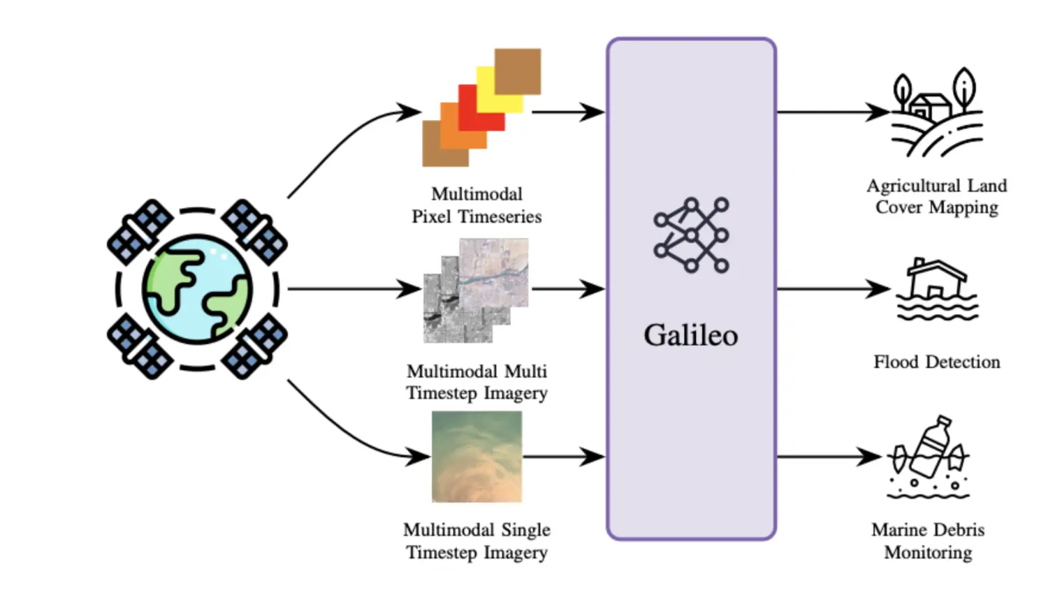
We introduce a highly multimodal transformer to represent many remote sensing modalities - multispectral optical, synthetic aperture radar, … (voir plus)elevation, weather, pseudo-labels, and more - across space and time. These inputs are useful for diverse remote sensing tasks, such as crop mapping and flood detection. However, learning shared representations of remote sensing data is challenging, given the diversity of relevant data modalities, and because objects of interest vary massively in scale, from small boats (1-2 pixels and fast) to glaciers (thousands of pixels and slow). We present a novel self-supervised learning algorithm that extracts multi-scale features across a flexible set of input modalities through masked modeling. Our dual global and local contrastive losses differ in their targets (deep representations vs. shallow input projections) and masking strategies (structured vs. not). Our Galileo is a single generalist model that outperforms SoTA specialist models for satellite images and pixel time series across eleven benchmarks and multiple tasks.